Japan Summer 2024 - Day 4 • Nojiri to Minokamo
Japan Summer 2024 - Day 4
May 30, 2024
Nojiri to Minokamo 110Km
Start 8:04AM Finish 6:22PM
Total Duration 10:18
Moving Time 7:15
Stopped Time 3:03
Ascent 1362m
Descent 1787m
Tour Total 459Km
Details at: https://ridewithgps.com/trips/184082376
I slept great on the futon atop the tatami mats in my room at the Atera-so Forest Spa. Bright light began pouring into my window early in the morning, but I was able to roll over and get a little bit more sleep. I finally got up, shaved, and had myself another soak in the onsen. I then enjoyed a cold coffee in my room before packing up riding back down to the river. I admired the twin arch bridges with gorgeous mountains in the distance. It's really beautiful here. I was wearing my bib shorts, short sleeve jersey, UV arm protectors and socks. The sun was strong. I crossed over the Kiso river and continued following it downstream. Instead of Highway 19 the route took a one lane road adjacent to the railroad track.
The route brought me back to Highway 19 where I rode the tiny space between the drainage ditch and the fast moving traffic. It really takes nerves of steel to do this, and I don't think many people could manage. I refused to let the fear enter my mind.
I rode across the old wood frame Momosuke suspension bridge, built in 1922. The route left Highway 19 and went straight up the side of a steep hill. I was now riding an original and iconic section of the Nakasendo, the Edo period land route between Tokyo to Kyoto. I passed various hikers and stopped to visit the Kabuto Kannon Temple, where I drank some spring water and signed a guest book. I passed bamboo groves and noticed green banners lining the route.
I stopped to visit the Waki-honjin Okuya local history museum in Nagiso, and was given a tour. I learned that the buildings were constructed out of cypress, and that the bamboo came all the way from Kyushu. I learned that they constantly kept a small fire going in the building to allow soot to build up on the interior surfaces of the house. These were then rubbed down for a smooth polish which protects the wood from insects. I learned that during the Edo period, the trip would take fourteen days by foot, which was pretty remarkable. I was doing it in six.
I continued and began following the Araragi river upstream. The climb began up towards the pass and fortunately there were switchbacks. I was accompanied by hikers, and there was a little traffic on two-lane Highway 7. I summited Magome Pass and entered Gifu Prefecture at 11am.
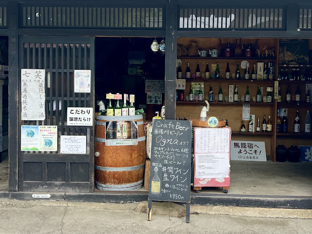
I rode through the beautiful old little town of Magome. It was chocked-full of tourists. I was able to get a craft IPA and some cheese sticks as well as some meat and bean paste oyama.
I began riding downhill and rode through a short tunnel. I kept my sunglasses on, and there was helix at the far end which brought me down to where I crossed the Kiso river.
I rode through Nakatsugawa and began following the Kawakami river upstream. It was now overcast.
I was hot and stopped at a roadside vending machine for a Ginger ale. In Tsukechicho I picked up the next route segment. I stopped at a Family Mart for two onigiri and a lemon soda.
I followed two-lane Highway 256 up a hill alongside moderate motor traffic. I pedaled through a tunnel where there was a sidewalk and railing between me and the traffic. The motor traffic noise reverberates in the tunnels, and it's loud.
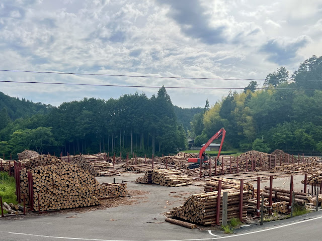
I came to a second tunnel, but stayed on the roadway because it was shorter. There are so many lumberyards in this part of the country. I realized that I've seen no livestock
I was now following the Shirakawa river downstream.
I passed orchards of green bushes and noticed they were being harvested. I stopped to ask, and learned that they were green tea leaves.
I rode through a narrow valley, with steep tall hills lined with cedar trees. I reached Shirakawa at 4:50pm. The weather forecast called for rain all night long and early tomorrow morning so I booked a hotel at my destination 43km away in Minokamo.
My phone was low on power, and my battery pack refused to charge it. I conserved power by not using my phone. Meanwhile I rode through three tunnels riding on and off highway 41 which paralleled the Hida river. As I descended, the valley grew wider and the hills began to recede.
Minokamo marks the confluence of the Kiso and Hida rivers, and it stands at only 240' elevation. The splendid Japanese alps were now behind me.
I checked into the Hotel R9 The Yard, a collection of shipping containers converted into hotel rooms. I took a shower and then rode over to Shiawaseya Imawatari. Here I enjoyed an iron plate miso pork cutlet, which is a regional specialty of Nagoya.
 |
| My accommodations for the night |
 |
| Bridges over the Kiso and Atera Rivers |
 |
| Momosuke Bridge |
 |
| Spring water at Kabuto Kannon Temple |
 |
| Traditional wooden housing at Nagiso on the old Nakasendo |
 |
| Waki-honjin Okuya local history museum in Nagiso |
 |
| Waki-honjin Okuya local history museum in Nagiso |
 |
| Waki-honjin Okuya local history museum in Nagiso |
 |
| Traditional wooden housing at Nagiso on the old Nakasendo |
 |
| Local delicacy store in Magome |
 |
| Drying firewood |
 |
| Timber operation |
 |
| Dinner at Shiawaseya Imawatari in Minokamo |
 |
| Map / Elevation profile |

Comments
Post a Comment